I am designing a program to detect objects in bird’s eye drone images. I have trained the YOLO model with my dataset and the classes I want and it works fine, but I have a shortcoming. What I want is to create a mechanism that checks whether the landing zones are available for 2 classes and how I don’t know what to do. I’m using OpenCV. I’m giving a few examples for better understanding.(I have 4 classes )
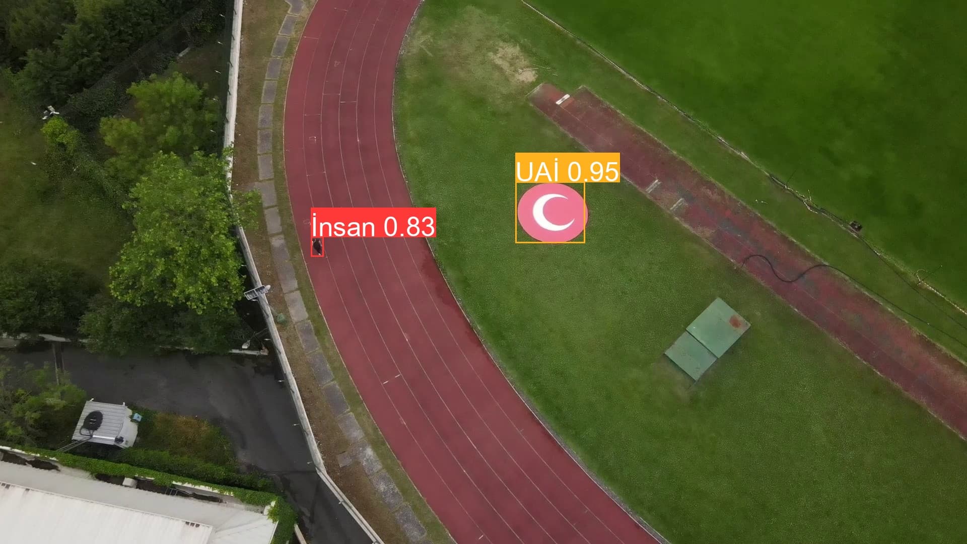
In the following image, there are two objects named “UAP” and “İnsan” in the image, and since “UAP” is our landing area, the landing area is available, I should get a feedback called “Landing area is available”:

In the other image, the object named “İnsan” rests on the region named “UAP” and I should get a feedback called “Landing area is not suitable”:

I want the same feedback that will apply to the “UAP” class to be valid for the “UAİ” class:
It would be more helpful if you could post a directive or document because I want to understand the principle. Or you can write the code directly, I can examine it.
My experimental half OpenCV code is here:
import numpy as np
import cv2
step 1 - load the model
net = cv2.dnn.readNet(‘best.onnx’)
step 2 - feed a 640x640 image to get predictions
def format_yolov5(frame):
row, col, _ = frame.shape
_max = max(col, row)
result = np.zeros((_max, _max, 3), np.uint8)
result[0:row, 0:col] = frame
return result
image = cv2.imread(‘datasets/Test/frame_014348.jpg’)
input_image = format_yolov5(image) # making the image square
blob = cv2.dnn.blobFromImage(input_image , 1/255.0, (640, 640), swapRB=True)
net.setInput(blob)
predictions = net.forward()
step 3 - unwrap the predictions to get the object detections
class_ids = []
confidences = []
boxes = []
output_data = predictions[0]
image_width, image_height, _ = input_image.shape
x_factor = image_width / 640
y_factor = image_height / 640
for r in range(25200):
row = output_data[r]
confidence = row[4]
if confidence >= 0.4:
    classes_scores = row[5:]
    _, _, _, max_indx = cv2.minMaxLoc(classes_scores)
    class_id = max_indx[1]
    if (classes_scores[class_id] > .25):

        confidences.append(confidence)

        class_ids.append(class_id)

        x, y, w, h = row[0].item(), row[1].item(), row[2].item(), row[3].item()
        left = int((x - 0.5 * w) * x_factor)
        top = int((y - 0.5 * h) * y_factor)
        width = int(w * x_factor)
        height = int(h * y_factor)
        box = np.array([left, top, width, height])
        boxes.append(box)
class_list = []
with open(“config.txt”, “r”) as f:
class_list = [cname.strip() for cname in f.readlines()]
indexes = cv2.dnn.NMSBoxes(boxes, confidences, 0.25, 0.45)
result_class_ids = []
result_confidences = []
result_boxes = []
for i in indexes:
result_confidences.append(confidences[i])
result_class_ids.append(class_ids[i])
result_boxes.append(boxes[i])
for i in range(len(result_class_ids)):
box = result_boxes[i]
class_id = result_class_ids[i]

cv2.rectangle(image, box, (0, 255, 255), 2)
cv2.rectangle(image, (box[0], box[1] - 20), (box[0] + box[2], box[1]), (0, 255, 255), -1)
cv2.putText(image, class_list[class_id], (box[0], box[1] - 10), cv2.FONT_HERSHEY_SIMPLEX, .5, (0,0,0))
print(box,class_id)
if class_id >= 2:
    print("İniş alanı tespit edildi")
elif class_id <= 1:
    print("İniş alanı değil")
cv2.imwrite(“Saving/image.png”, image)
cv2.imshow(“output”, image)
cv2.waitKey()